
Earth Explorer is a free and reliable world map software for all users. This is the product that can..
2018| License: Free |
| Released: Motherplanet |
| Request: Windows XP/Vista/7/8/10 |
| Last updated: 19-08-2021 |
| OS: Window |
| Version: 2018 |
| Total download: 4194 |
| Capacity: 16 MB |
Earth Explorer is a free and reliable world map software for all users. This is the product that can replace Google Earth. With the latest version Earth Explorer 2018, it is a must-have tool for any amateur geographer who wants to. Explore the world map in detail.
Earth Explorer 2018 displays a very clear and intuitive 3D earth map, next to a panel of information about countries, cities and islands . Click on each item to see its location on earth, scroll further on that table to read more data such as population, area, and capital city name. Users of Earth Explorer on PC will also be able to zoom in on any area on the map, display high-resolution satellite imagery, or calculate the distance between two points. The program is set up to show different viewing locations, such as riverside roads, major cities or ongoing earthquakes.
For students, Earth Explorer 2018 is an invaluable resource. Besides, this is also the perfect tool for anyone who is passionate about geography and wants to expand their knowledge about the earth, countries and regions.
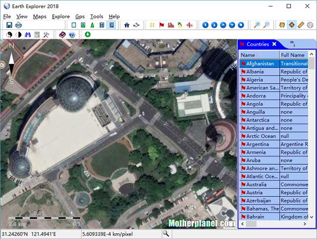
Earth Explorer is digital map software based on the worldwide positioning system GPS with high quality satellite imagery, topographic imagery or a combination of the two. strong>Earth Explorer provides geographic information for 270 countries and territories, more than 50,000 cities, more than 15,000 islands, and more than 50,000 earthquakes since 1973. And yet, a map of the earth. This useful also provides general information about border regions, river systems, lakes and sea routes around the world. Map information is further integrated together to provide a beautiful 3D image of the earth. You also have the right to place your own landmarks and your own route on the map, display the GPS location and store it with the map when connected to a GPS device. Earth Explorer 2018 provides users with many interesting functions for scientific research, study and life.
The Weather 14 days is a handy, accurate and free 14-day weather ..
Zimbra Desktop is an open source software that allows users to br..
LINE is a free, multi-featured messaging and calling app with an ..
Skype is a free messaging, calling, video calling app with good q..
Mailbird 2.5.43.0 is a utility designed to help users manage thei..
5
4
3
2
1